
When a commercial building envelope develops a leak, the visible water dripping into your warehouse, logistics hub, or corporate facility is rarely the start of the problem. It is usually the final stage of a silent, destructive process occurring deep within the roofing substrate. Traditional leak detection often relies on visual inspections or destructive core sampling—methods that either guess at the source or compromise the roof’s integrity to find the breach.
Deploying advanced drone thermal imaging for roofs changes this dynamic entirely. By capturing non-destructive, high-resolution infrared telemetry from the sky, facility managers can accurately map subsurface anomalies, locate trapped moisture before it destroys structural decking, and make data-driven asset management decisions.
Quick Take: Infrared Sub-Surface Diagnostics
- Thermal Retention: Water features a high thermal mass; it absorbs heat during sunny hours and retains it far longer than surrounding dry insulation membranes after sunset.
- Targeted Resolution: Aerial drone thermal imaging pinpointing specific thermal variations allows facilities to execute isolated, modular surgical repairs instead of ordering complete, premature replacements.
- Expense Protection: Discovering compromised sub-surface substrate areas early helps mitigate catastrophic decay in structural corrugated steel or wood roof decking.
- Efficiency Gains: Transitioning from manual physical inspection tracking to automated unmanned aerial vehicle (UAV) thermal scans slashes commercial diagnostics timelines from days to hours.
The Physics of Commercial Infrared Roof Scans
To understand why traditional visual inspection fails, you have to look at how thermal energy interacts with industrial roofing assemblies. A standard low-slope commercial roof consists of a structural deck, a vapor barrier, rigid insulation boards (such as polyisocyanurate), and a waterproofing outer membrane like TPO or EPDM.
+-----------------------------------------------------------+
|          Waterproofing Membrane (TPO / EPDM)               |
+-----------------------------------------------------------+
|  ~~~~~~ Sub-surface Moisture Trapped Under Membrane ~~~~~ | <-- Retains heat after sunset
+-----------------------------------------------------------+
|          Rigid Insulation Boards (Polyiso)                |
+-----------------------------------------------------------+
|          Structural Roof Deck (Steel / Concrete)           |
+-----------------------------------------------------------+
When an outer membrane suffers a microscopic puncture or a seam separation occurs, rain or condensation migrates downward, saturating the porous rigid insulation below.
This creates a phenomenon rooted in thermodynamics: solar capacitance. During daylight hours, the sun heats the entire roof structure uniformly. When night falls and the ambient temperature drops, dry roofing materials cool down rapidly, shedding their thermal energy into the atmosphere.
Saturated insulation boards behave differently. Water requires significantly more energy to change temperature compared to dry foam or rubber—a characteristic known as high specific heat capacity. Consequently, the wet areas of the insulation act as thermal reservoirs, holding onto daytime heat long after the surrounding dry roof sections have cooled down.
After Sunset Radiative Cooling:
Dry Membrane Area ----> Cools Rapidly ----> Appears Dark/Purple on FLIR
Wet Insulation Area --> Retains Heat ------> Appears Bright Yellow/Red on FLIR
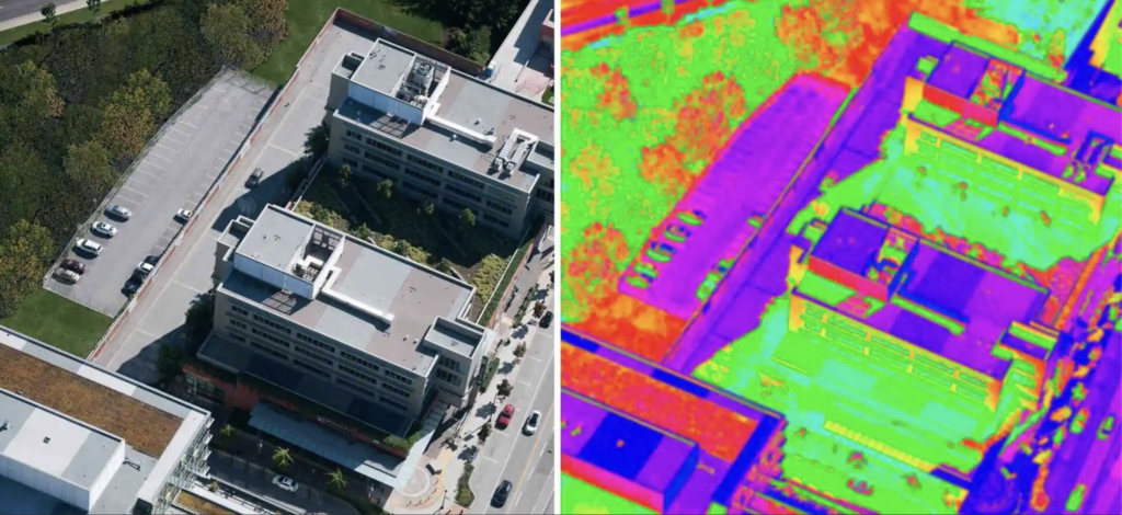
An aerial platform equipped with a calibrated Radiometric FLIR (Forward Looking Infrared) sensor captures this exact temperature Delta. Saturated insulation appears on a thermal map as a distinct, glowing hot spot or anomaly against a uniform dark background.
Visualizing Sub-Surface Trapped Moisture
Implementing specialized software lets drone operators generate precise radiometric orthomosaics. These are high-resolution, stitched-together thermal maps where every single pixel contains accurate temperature information.
Rather than merely indicating that an area is hot or cold, these systems quantify the exact thermal variation across the building envelope. This level of insight allows technical experts to distinguish between active moisture anomalies and common false positives like exhaust vent plumes, internal building heat signatures, or structural solar glare reflections.
The Three Most Common Technical Roadblocks of Manual Core Testing
Historically, verifying moisture inside a commercial roofing assembly required an estimator to perform destructive core testing or walk the deck with handheld electronic moisture meters. These outdated approaches introduce significant business liabilities:
1. Membrane Structural Compromise
Core testing forces the technician to physically cut an actual 2-inch to 4-inch cylinder straight through your operational waterproofing membrane down to the structural deck. Even when patched correctly, every manual core cut creates a permanent weak point in the building envelope, introducing an artificial failure vector where future water intrusion can develop.
2. High Statistical Error Margins
A manual physical inspection is fundamentally constrained by human mobility. Taking ten core samples across a massive 150,000-square-foot industrial logistics hub represents less than 0.01% of the total surface area. Saturated insulation pockets located just inches away from a dry core sample site will go entirely unnoticed, leading to inaccurate diagnostic profiles.
3. Safety Risks and Extended Labor Timelines
Sending personnel to walk along low-slope perimeters, navigate structural parapets, and climb access ladders while carrying heavy diagnostic gear introduces serious workplace safety risks. Additionally, mapping a large industrial roof layout manually takes several days of labor, creating logistical friction for fast-moving enterprise operations.
Operational Workflow of a Precise UAV Thermal Roof Inspection
Executing a successful commercial drone inspection requires careful coordination across flight parameters, weather dynamics, and hardware calibration. An expert enterprise drone workflow follows a strict, multi-step process to ensure data accuracy:
[Phase 1: Environment Calibration]
   - Verify zero daytime rain & high solar loading
   - Wait for evening ambient drop (>15°F Delta)
         |
         v
[Phase 2: Autonomous Flight Execution]
   - Deploy UAV with Radiometric FLIR Sensor
   - Flight path grid layout with 80% overlap
         |
         v
[Phase 3: Thermal Mapping & Stitches]
   - Process radiometric data into an orthomosaic map
   - Isolate real moisture anomalies from false positives
         |
         v
[Phase 4: Targeted Verification & Repair]
   - Conduct non-destructive moisture verification
   - Deliver precise CAD/GIS repair coordinates
Phase 1: Environmental Condition Selection
A thermographic drone flight cannot simply occur at any time. The roof surface must be completely dry, free of standing puddles or condensation, and must have received strong daytime solar exposure.
The optimal flight window opens approximately 1 to 2 hours after sunset, when the ambient temperature differential between dry and wet areas reaches its peak—ideally a minimum Delta of 15°F. Winds must remain low (under 12 MPH) to prevent convection from dissipating the roof’s surface heat prematurely.
Phase 2: Autonomous Grid Flight Execution
The flight path is programmed into an autonomous mission planner rather than flown manually. The UAV traverses the roof structure using a methodical zigzag grid pattern, maintaining a consistent altitude to ensure uniform ground sampling distance (GSD).
The flight planning application locks in a strict 80% front-lap and 80% side-lap configuration. This deep overlay ensures that every square inch of the roof deck is photographed from multiple angles, which is required to prevent geometric distortion during the automated image stitching process.
Phase 3: Orthomosaic Processing and Delta Interpretation
The raw radiometric imagery is fed into specialized photogrammetry and thermal analysis software suites. The platform aligns the overlapping images, normalizes variations in angle, and renders an accurate, comprehensive map of the entire asset.
Analysts then use custom digital color palettes (such as FLIR Ironbow or Arctic profiles) to clearly separate real moisture retention anomalies from ambient structural heat signatures.
Phase 4: Field Verification and Targeted Remediation
Once the thermal anomalies are identified, targeted validation is performed using non-destructive moisture meters or capacitance probes directly on the marked zones. This converts the thermal data into actionable construction blueprints. Instead of facing a costly, unneeded total roof tear-off, facility managers receive exact coordinates to replace only the compromised insulation boards and patch the entry membrane splits.
How Drone Thermal Diagnostics Enhances Asset Lifecycle Strategies
Using drone thermal imaging for roofs shifts commercial real estate management away from reactive damage control and toward data-driven, predictive commercial roof maintenance protocols. This modern approach delivers clear advantages over traditional roofing workflows:
| Performance Metric | Traditional Manual Diagnostics | Advanced UAV Drone Thermal Scanning |
| Inspection Timeline | 2 to 4 Operational Workdays | 1 to 3 Flight Hours Per Facility |
| Structural Integrity Risk | High (Requires Destructive Core Cuts) | Zero (Non-Invasive Remote Telemetry) |
| Data Capture Coverage | Limited Spot Checking (< 1% Surface) | Comprehensive Matrix Coverage (100% Surface) |
| Localization Precision | Approximated via Visual Leak Tracing | Pinpoint Sub-surface GIS Coordinate Mapping |
| Long-Term Capital ROI | High Amortization (Early Replacement) | Optimized Asset Extensions (Modular Patches) |
Real-World Case Study: Preserving a Multi-Family Asset Portfolio
Consider a regional multi-family housing complex consisting of six low-slope apartment blocks with a total combined roofing surface area of 180,000 square feet. The property management firm faced persistent interior ceiling leaks in two buildings, and an initial manual inspection company recommended a complete replacement of the TPO membranes across the entire asset portfolio, quoting an estimated capital expenditure of $840,000.
Seeking a more rigorous analytical look before approving such a large expenditure, the firm brought in an advanced technical contractor to conduct a comprehensive automated UAV thermal roof inspection.
The Diagnostic Findings
The evening drone thermal scan mapped all six buildings in less than three hours of total flight time. The processed thermal orthomosaic maps revealed that across four of the apartment blocks, the insulation substrate remained completely dry, and the visible interior water tracking stemmed from minor localized flashing splits around HVAC equipment curbs.
On the two leaking buildings, the thermal signature identified that sub-surface moisture saturation was tightly confined to two isolated rectangular zones near clogged primary drain scuppers, affecting less than 12% of the overall structural roof footprint.
The Financial Outcome
Equipped with precise sub-surface moisture maps, the asset team avoided a total portfolio tear-off. Instead, they executed a targeted, surgical repair protocol:
- Replaced only the saturated insulation boards within the specific thermal anomaly boundaries.
- Flushed out the restricted drainage scuppers and installed reinforced boots around the HVAC curb flashings.
- Applied a protective, high-solids elastomeric silicone coating over the existing TPO surfaces to extend the overall building envelope lifetime by an additional ten years.
The total cost for these targeted interventions came out to $98,000, saving the property management firm $742,000 in unnecessary capital expenditures while maintaining the asset’s structural integrity.
Aligning Enterprise Inspections with Commercial Standards
For drone thermal imagery to hold up in commercial real estate transactions, insurance adjustments, or warranty claims, the scan must follow standardized engineering protocols. Commercial thermal surveys should comply with ASTM International guidelines, specifically ASTM C1153: Standard Practice for Location of Wet Insulation in Roofing Systems Using Infrared Imaging.
Adhering to these rigorous benchmarks ensures that all thermographic data collected by an unmanned aerial vehicle meets the technical standards required by structural engineers, commercial field adjusters, and institutional asset inspectors.
Working with an advanced, elite roofing group like Kelly Roofing USA ensures your diagnostic pipeline leverages high-integrity engineering standards. Their specialized technical teams deploy advanced UAV flight systems, highly accurate radiometric FLIR sensors, and detailed software processing models designed for commercial, industrial, and multi-family infrastructure.
Implementing this caliber of advanced thermal tracking lets property managers identify building envelope vulnerabilities early, protect internal assets, and optimize long-term operational budgets.
FAQ Section: Understanding Drone Thermal Diagnostics
Can a drone thermal scan locate leaks during daytime hours?
No. Drone thermal imaging for roofs relies on solar capacitance and radiative cooling, which requires a significant temperature differential between dry and wet insulation. This Delta peaks roughly 1 to 2 hours after sunset as dry materials cool rapidly while water-saturated sections retain heat. Daytime scans often run into severe thermal distortion caused by solar glare and reflective surface heat.
Will an infrared camera show a leak through standing ponding water?
No, standing water on the exterior membrane blocks the infrared sensor from reading the underlying insulation layers. The high thermal mass of surface water masks the subtler temperature differences of sub-surface saturated insulation. The roof surface must be completely dry before starting a drone thermographic flight.
Does drone thermal imaging work on all commercial roofing materials?
It is highly effective on low-slope commercial membranes like TPO, EPDM, PVC, and built-up asphalt roofs (BUR). However, unpainted, highly reflective bare metal roofs pose unique challenges due to low emissivity—meaning they reflect background atmospheric thermal signatures rather than emitting their own heat. Bare metal systems require specialized calibration angles or alternative diagnostic methods.
How precise are the moisture location maps generated by a drone?
The final radiometric orthomosaic maps are highly accurate, often yielding sub-inch ground sampling distance (GSD) resolution. This creates a detailed map where structural issues and sub-surface moisture pockets can be pinpointed within inches of their actual physical location on the roof deck.
Can drone thermal scans replace manual core sampling entirely?
While drone thermal scans reduce the need for destructive testing by up to 95%, standard commercial engineering guidelines still call for minimal non-destructive field verification (such as using a capacitance moisture meter or taking a targeted core sample) to confirm the thermal findings before finalizing insurance claims or large-scale restoration projects.
Summary of Next Steps
Protecting an industrial or commercial building envelope requires moving away from guesswork and adopting empirical, data-driven diagnostic methods. Utilizing drone thermal imaging for roofs uncovers hidden sub-surface issues before they evolve into costly structural failures, allowing facility managers to optimize their maintenance budgets and maximize long-term asset lifecycles.
If you are currently overseeing a large commercial facility, managing a multi-family real estate portfolio, or preparing for upcoming seasonal facility audits, scheduling a modern aerial thermographic evaluation is a reliable way to verify your building’s true structural health. Partnering with professional envelope specialists like Kelly Roofing USA provides the precise analytics, high-resolution telemetry, and actionable repair frameworks needed to secure your infrastructure for years to come.